pgc-h-arrow-right" style="box-sizing: border-box; font-size: 1.5em; margin-right: 0px; margin-bottom: 0px; margin-left: 0px; padding: 0px; border: 0px; line-height: 1.33333; color: rgb(34, 34, 34); position: relative; font-family: "PingFang SC", "Hiragino Sans GB", "Microsoft YaHei", "WenQuanYi Micro Hei", "Helvetica Neue", Arial, sans-serif; white-space: normal; background-color: rgb(255, 255, 255); text-indent: 2em; margin-top: 28px !important;">概述:
水雨情监测系统是一种重要的山洪灾害防治工程措施。水雨情监测系统集信息采集、传输、分析和预警等多功能于一体,实现了预警信息及时、准确地上传下达,从而使可能受灾区域能够及时采取措施、最大限度地减少人员和财产损失。
水雨情一体化自动监测站集一系列的水雨情设备于一体,实时监测水雨情状况,采集小型水库图像、视频等信息,是掌握水库蓄水状态、预警安全事故、辅助防汛抗洪的忠实情报员。

pgc-h-arrow-right" style="box-sizing: border-box; font-size: 1.5em; margin-right: 0px; margin-bottom: 0px; margin-left: 0px; padding: 0px; border: 0px; line-height: 1.33333; color: rgb(34, 34, 34); position: relative; font-family: "PingFang SC", "Hiragino Sans GB", "Microsoft YaHei", "WenQuanYi Micro Hei", "Helvetica Neue", Arial, sans-serif; white-space: normal; background-color: rgb(255, 255, 255); text-indent: 2em; margin-top: 28px !important;">系统组成:
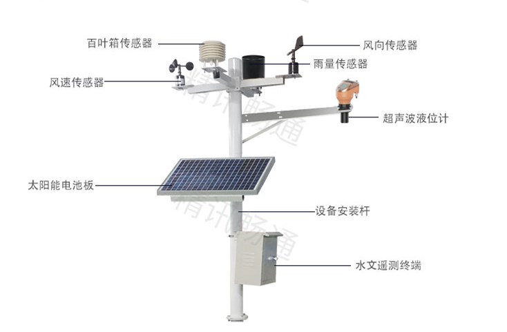
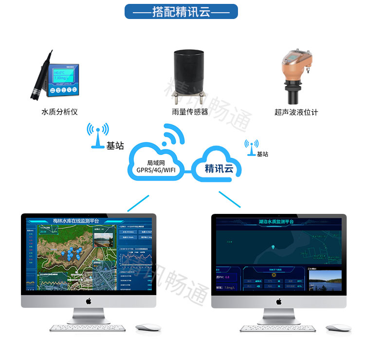
水雨情监测系统一般由中心站和遥测站(监测站)组成。 遥测站(监测站)主要监测各个水库湖泊的实时水位、降雨量、现场图像等数据信息,并上传至中心站。中心站通过相应的软件平台,接收并处理由遥测站发出的数据,根据需求向决策者提供至关重要的信息。同时系统可通过WEB、专属移动端、短信等方式快速发布相关水雨情信息。
pgc-h-arrow-right" style="box-sizing: border-box; font-size: 1.5em; margin-right: 0px; margin-bottom: 0px; margin-left: 0px; padding: 0px; border: 0px; line-height: 1.33333; color: rgb(34, 34, 34); position: relative; font-family: "PingFang SC", "Hiragino Sans GB", "Microsoft YaHei", "WenQuanYi Micro Hei", "Helvetica Neue", Arial, sans-serif; white-space: normal; background-color: rgb(255, 255, 255); text-indent: 2em; margin-top: 28px !important;">系统特点
●一体式立杆设计,可实现前端站点的快速调试与部署。
●采用激光水位计进行多种水位监测,丈量精度高,抗干扰能力强。
●采用无线传输方式,突破地域限制,适应性强。
●基于自主研发的无线RTU产品,可远程对设备进行调试维护。
●基于B/S架构的系统平台,可快速方便地对系统进行访问。
●专属客户端支持用户随时随地查看当前设备状态。
pgc-h-arrow-right" style="box-sizing: border-box; font-size: 1.5em; margin-right: 0px; margin-bottom: 0px; margin-left: 0px; padding: 0px; border: 0px; line-height: 1.33333; color: rgb(34, 34, 34); position: relative; font-family: "PingFang SC", "Hiragino Sans GB", "Microsoft YaHei", "WenQuanYi Micro Hei", "Helvetica Neue", Arial, sans-serif; white-space: normal; background-color: rgb(255, 255, 255); text-indent: 2em; margin-top: 28px !important;">系统功能:

